HOW THE SILK ROUTE SHAPED & WAS SHAPED BY THE HIMALAYAS
” The ordinary traveler would usually seek out the easiest route, stick to the existing tracks and climb only the unavoidable passes. The surveyor had to cover all the ground. He was after vantage points. Across empty, trackless regions he moved from one high peak to another. Mostly he traveled on foot; horses were useless. He was as much a mountaineer as a traveler, and this is the days before aerial surveys and wireless contact when there were no lightweight rations and no oxygen. Mountaineering skills amounted to strong lungs and a cool head and basic climbing equipment like a pick, a spade and thick coil of rope. No wonder Godwin Austen in his old age felt bitter about the technological dodges of the twentieth-century mountaineer. These surveyors were the true heroes of Himalayan exploration and have been forgotten in this day and age. These were Men who themselves were no less than any Mountain.”
John Keay – When Men and Mountains Meet: The Explorers of Western Himalayas: 1820 – 1875
The unforgiving and gargantuan Himalayas have captured the imagination of explorers across history and continues to cast its spell on today’s traveler.
What we see today as set Geo-Political boundaries and well- known destinations were once part of uncharted territory, its environs feared and respected by local communities; its mountain peaks worshiped. The areas that are now part of Himalayan holiday destinations, were once part of an ancient route network. A network that caused the genesis and flourishing of world trade and a number of ideas and practices that we take for granted today.
But, Let’s first begin with a brief outline of the Silk Route and what it enabled.
The Silk Route wasn’t a highway or singular road, rather a network of trading routes over land and sea, that enabled the exchange of various goods to numerous regions of the ancient world. The trade that ensued along with this network eventually gave rise to the ‘merchant class’ and also lead to a number of factors that impacted some of today’s paradigms. This ancient route not only circulated goods, but also exchanged the splendid cultures of China, India, Persia, Arabia, Greek, and Rome.
Because silk was the major trade product that traveled on this network of routes, it was named the Silk Road in 1877 by Ferdinand von Richthofen – a well-known German geographer.
The Silk route leads to wider global economic impact: Few people could afford silk but a lot of people were employed in its production, as the market for silk grew, more and more people got into silk production. This meant more hands getting paid and hence economies started to flourish or eventually imploded depending on their location or era in history.
The spread of global ideas: The Silk Route did not only trade luxury goods. Probably the most important good traded on the silk road was ideas – for eg, the silk road was the primary route for the spread of Mahayana Buddhism to the west. In fact, Buddhism was dwindling in India at the time, and its contact with other cultures further west allowed it flourish; making it the world religion it is today. Many merchants on the silk route eventually became strong patrons of monasteries which also became convenient weigh stations for trade caravans. The wealthy merchants were, in theory, purchasing a form of ‘divine’ insurance by supporting these monasteries and receiving the blessings of the monastery’s monks. It was a no – loss situation for both sides when you take into account that one of the prime materials used in rituals for Mahayana Buddhism is … silk.
The third – probably the darkest – was the global mix of human population the trade routes offered. This varied exchange led to a wider reach for diseases like measles, smallpox and even the bubonic plague; which quite possibly would not have spread to the west without the silk route.
If you look at the connections fostered by the silk road it affected way more people than just the ones rich enough to buy silk and definitely impacted our civilization as a whole.
For India, this had a major influence on the regions of the upper Himalayas, and as foreboding and challenging these regions were to access, they became an integral part of the trade for the ancient world and put high altitude towns like Leh (among others) on the world map. It’s a legacy that continues to this day, though the historic significance of these places is often overlooked due to the paradigm change of how trade is carried out today, touristification of these destinations, and contemporary
geopolitical boundaries as well.
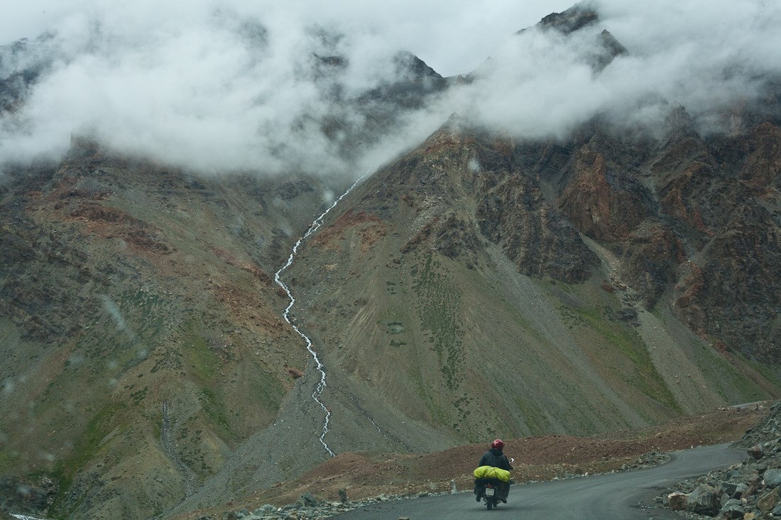
While the majority of trade goods from the plains of India came up through the town of Srinagar then over Zoji La and further through Leh. There were alternate routes that also existed. One such route used was from Skardu (capital of Baltistan) that ran through Khaplu (present-day, northern Pakistan area), crossed over Chorbat La (present-day, India region), continued into the Nubra valley, and then over Khardung La to finally reach Leh. There was a route from Kishtwar (present-day, Jammu region) crossing through Umasi La, which then continued further to the Zanskar region and then Leh. From Himachal Pradesh the town of Kullu served as stop point before crossing Rothang La, further through the Lahaul region, then Baralacha La and finally Leh. This last route is now the famous ‘ Manali – Leh highway’ that at one time could be considered the holy grail of motorcycling.
The town of Leh served as a large marketplace (by ancient standards). Traders of all cultures could be found passing through here as it was the point of convergence for various trade routes, and as such was an epicenter of all the trading conducted on this route. Products like Corals, Muslin, Tea, Shawls, and Indigo passed through Leh moving further north. Products like Silk, precious metals, costumes, jewelry and even strangely Russian currency during the end of the 19th century passed through; and further south from Leh.
Ldumra (the valley of flowers) or Nubra is a tri-armed valley located to the northeast of the Ladakh valley with an average elevation of 10,000 feet. The merging of the rivers Shyok and Nubra (also known as Siachen) forms this valley and separates the Ladakh and Karakoram ranges. The Sasser pass and Karakoram pass lie on the border of this cold desert valley and to it north lies the Siachen glacier. A popular site to see is the gigantic Maitreya Buddha statue at the village of Diskit which stands at an impressive 106 feet. One of the vestiges of the Silk Route trade is the Bactrian Camels which came to Nubra over the Passes from Central Asia and stayed. Unfortunately, these days we only see them only give joy rides to tourists.
A more remote place of interest (that has only recently been opened to tourists) is the village of Turtuk. The village lies on the banks of the Shyok river and is one of the few places to witness Balti culture in India. Its people are an ethnic group of Tibetan and Dardic descent who eventually grew weary of their long isolation (due to the village’s geopolitical location) & petitioned for it to be opened up to the rest of India. The village is the last outpost in India after which Pakistan-controlled Gilgit-Baltistan begins.
Leh
Like its cousins ‘ Manali and Old Manali’ in the Himachal Pradesh, the town of Leh is laid back and friendly. Journeying through its small lanes, one finds restaurants, travel agencies, souvenir shops; and further away from small whitewashed houses that are also relatively inexpensive home-stays and sometimes hotels. Located just a little ahead of the intersection between Yurthung and Changspa road is the vivid white Shanti Stupa atop a small hill. The views of Leh from here are worth the climb. Leh’s old town holds the stark but imposing Leh Palace and a maze of smaller lanes that zig-zag through its main market.
It’s easy to get into the vibe of Leh and is the best option to rest and acclimatize properly before heading out into the more remote regions of Ladakh’s cold desert.
Khardung La
Attempting the crossing of Khardung La is definitely a challenge. The harsh elements make quick work of decimating the road and sheer drops barely a few feet from your path are best not looked at. The high altitude takes your breath away but so does the reward of crossing into the spectacular winding roads of the Nubra Valley. At 5602m, Khardung La is claimed (and disputed) to be the world’s highest motorable pass. Khardung La is situated on one of the highest motorable roads in the Ladakh region. Earlier on the pass used to lie on a major caravan route from Leh to Kashgar in Central Asia. Today the pass is strategically important to India as it is used to carry supplies to the Siachen Glacier.